Sven AugustijnenMaps of the Middle East (1942 - 1969)
–
–
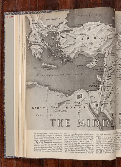
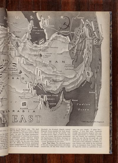
Sven Augustijnen’s (BE, 1970) exhibition Maps of the Middle East (1942-1969) consists of 71 photographs. Placed in a long line in Kunsthallens Gallery 2 and 3, the photographs present maps published in the American journal Time Magazine in the period 1943 to 1969. Most of the maps are geopolitical or of war zones, but there are also religious and archaeological maps. The exhibition title Maps of the Middle East (1942-1969) suggests how Western relations and views on the Middle East have evolved throughout the 20th century. With this exhibition, Augustijnen presents the development of the global political power and its focus, as well as the ways in which new nations have been born and have gained independence.
Time Magazine has been published weekly since 1923. The magazine is known for its red frame on its front pages and journalistic style, which is personal and narrative. Based on the maps in Time Magazine, Augustijnen points out that, in many ways, journalism has become a modern form of historical writing. Historical writing that cannot only be read as facts but also should be perceived as personal narratives and political attitudes. Cartography, or drawing a map, is an attempt to map out and measure the world based on logical reasoning. As new technology is developed and political decisions change national borders, older maps are replaced by new, overwritten like palimpsests.
With the exhibition Maps of the Middle East (1942-1969), Augustijnen works opposite the idea of the blank palimpsests, used in the Middle Ages to change or overwrite text on parchment. He does not overwrite the story we know, but strives to nuance and show its origins. In Maps of the Middle East (1942-1969) it becomes clear that even though we think we can measure the world objectively, the map is not just a practical tool that shows us national borders, mountain formations and oceans. It is a visual symbol of the discourses and power factors that give rise to this measurement. With his photographic documentation of existing sources, Augustijnen tries to uncover these conditions and make visible the context of the map. As Augustijnen writes: "Insofar as an Empire draws the maps of the regions under their influence, it also draws a portrait of itself." For Augustijnen, this visualization of historical writing is an artistic method of seeing and remembering the story as it unfolded and still unfolds. The lines and boundaries in the cards from Time Magazine are still visible today in our political systems and the ways in which we view the world.
Sven Augustijnen's investigative artistic work and studies of historical writing permeate his practice. Studies of how history is created by narratives, which may be untrue and documents that may be false – truth can be manipulated, distorted and undermined. Maps of the Middle East (1942-1969) is an extension of Augustijnen's investigative practice and a deconstruction of historical writing as a genre. By this means, the maps become a symbol of the world, which repeats the same mistakes and engenders the same human tragedies in a continuous hunt for dominance and power.
Maps of the Middle East (1942-1969) in Kunsthal Aarhus is the first solo exhibition with Sven Augustijnen in Denmark.
Supported by